Voter
2017-05-08 01:38:38 UTC
A drought could come back at any time, and last for years or decades.
A water shortage in the state of California is unacceptable.
California needs a canal from Oregon to the 2 great lakes in Northern California -
Lake Trinity and Lake Shasta.
Farmers should never be without water in the U.S.A. Farms and universities are
among the foundations of any country.
http://en.wikipedia.org/wiki/List_of_largest_reservoirs_of_California
http://en.wikipedia.org/wiki/Trinity_Lake
http://en.wikipedia.org/wiki/Shasta_Lake
Okay, here is a repost of what I have learned in case anyone is interested in
this, and it helps anyone to have these links (below).
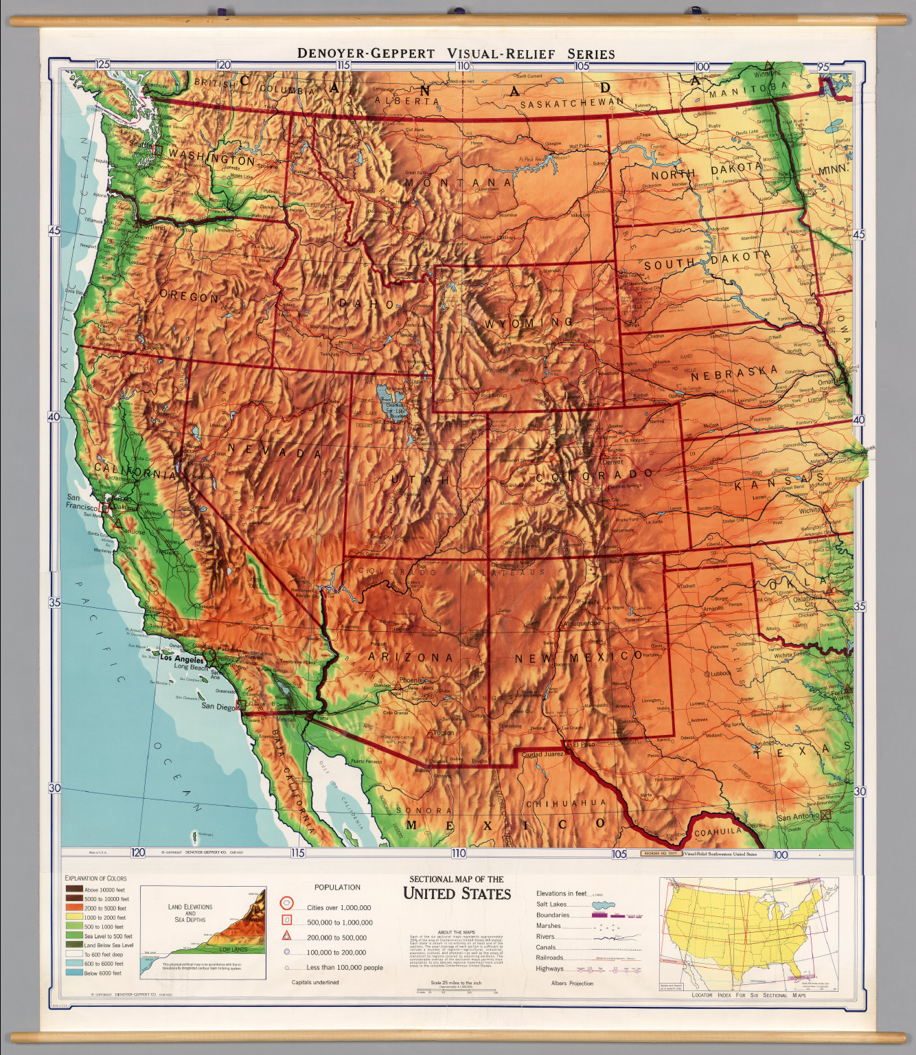
3 rivers cross the Cascades, the Columbia River, the Klamath River, and the
Pit River. The Columbia River runs through the Portland/Vancouver, Oregon
area in the north of Oregon State, and forms most of the border between
Oregon State and Washington State.
The Klamath River and the Pit River cross the Cascades in Northern
California. The Klamath River connects to Trinity Lake through the Trinity
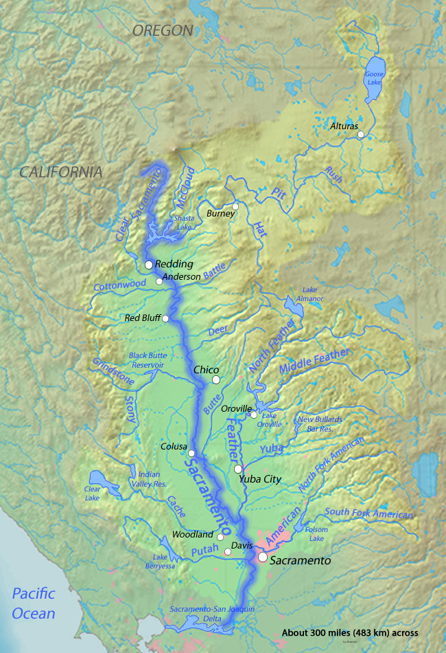
River, and the Pit River connects directly to Lake Shasta. This map shows
the Cascades range and the rivers:
Loading Image...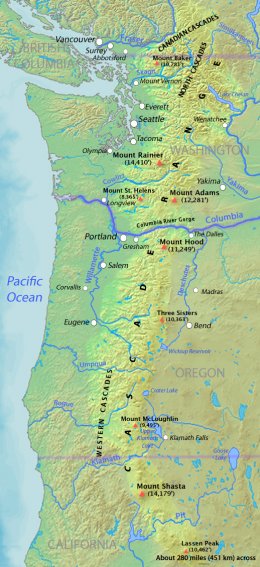
One idea is to get more water into Lake Trinity or into Lake Shasta, so we
can get more water out of them.
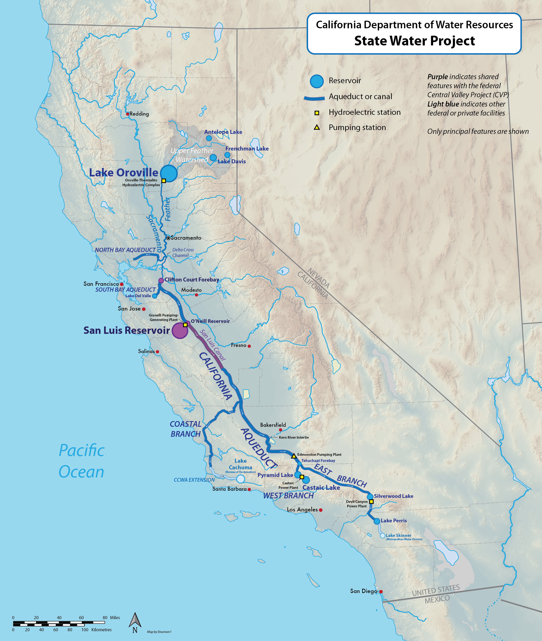
But no one even yet answered my question: Do our canals even carry water to
the Central Valley from these effectively yet? The map of the California
water systems doesn't indicate:
Loading Image...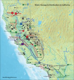
It looks like they connect to the Sacramento River.
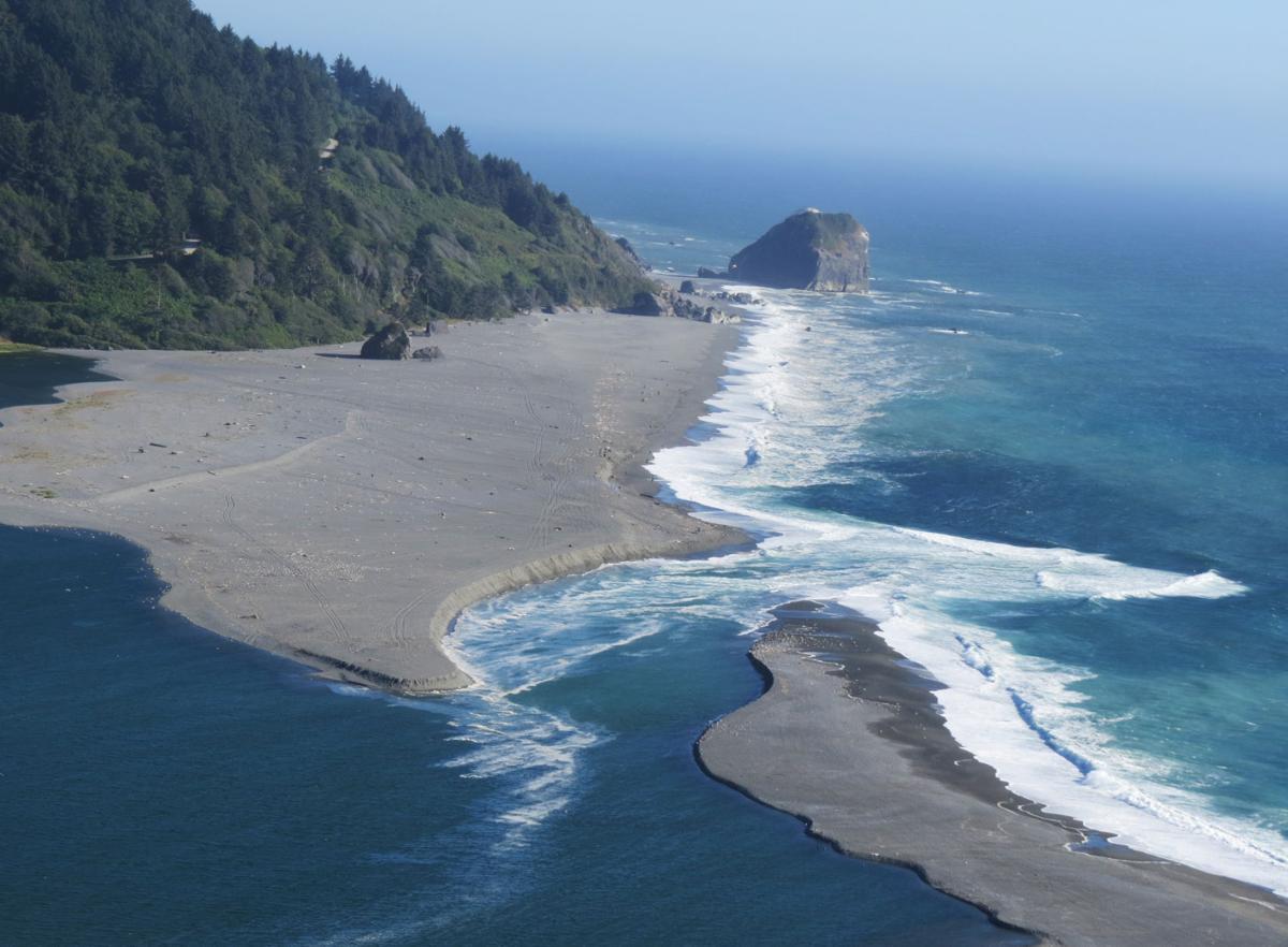
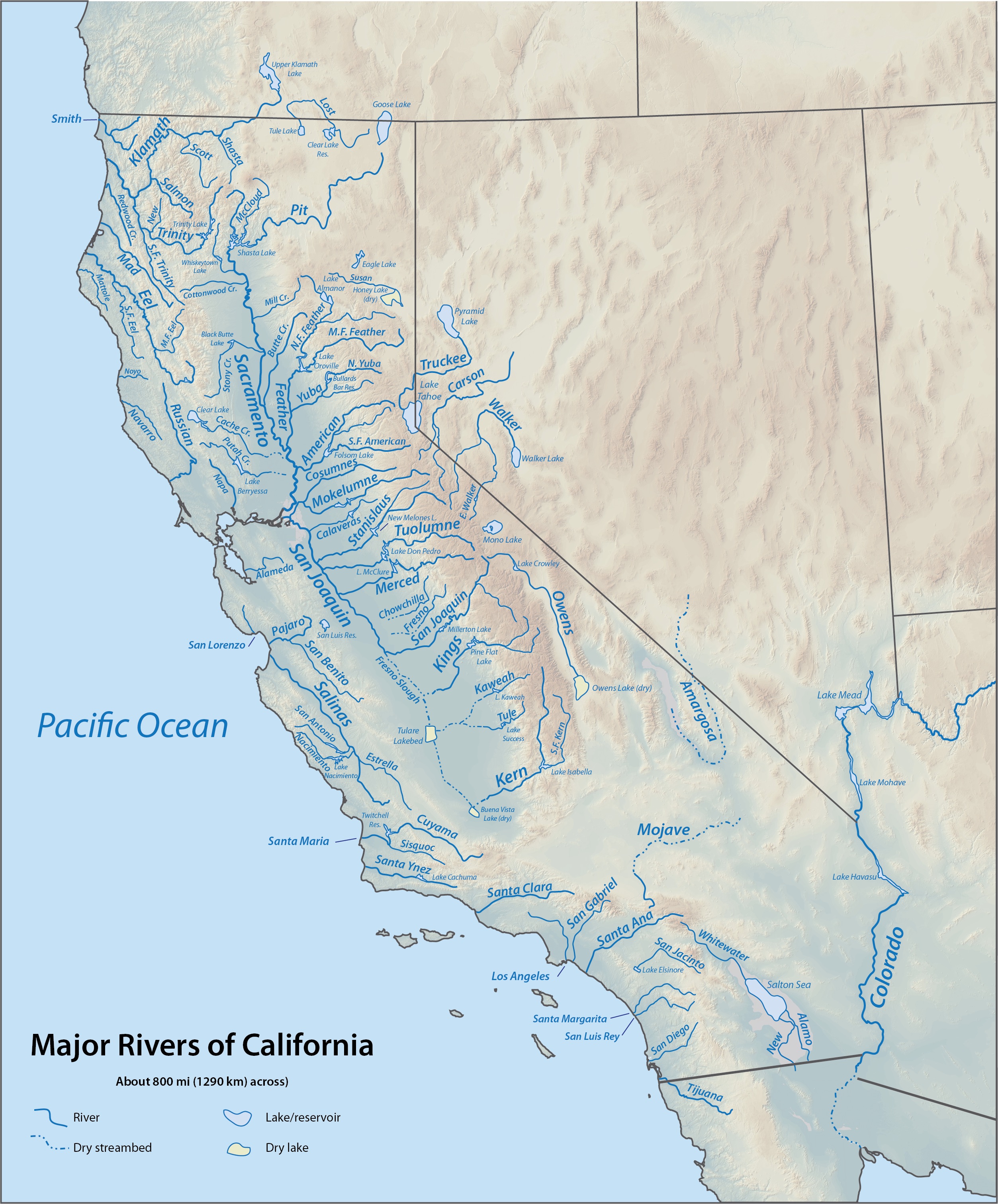
However another idea is to make another Lake/Reservoir like Lake Trinity out
of the Klamath River. This river apparently is currently emptying into the
ocean. A lake just past the South Fork of the Trinity River might be a
possible location. The South Fork already connects to the Lake Trinity.
Another idea could be anywhere along the South Fork of the Trinity River
after the part that connects to Lake Trinity branches off:
Loading Image...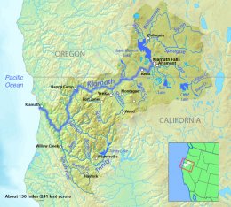
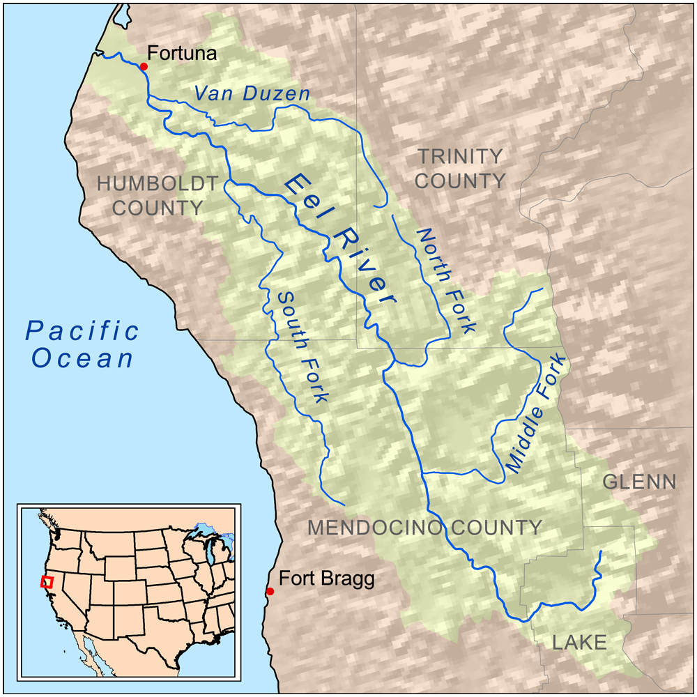
If not these, perhaps there's another river that can be turned into a
greater reservoir somewhere else in the state. I included some maps of all
the rivers below.
As for connecting California's Lakes and River's to greater water sources,
the Columbia River, along the Northern Oregon border, may be the first
Northern point, connecting it to the Klamath River of the Pit River. The
major rivers that run through Oregon, and connect to the Columbia River
however, the Willamette River, and the Deschuttes River, both run South to
North.
Perhaps we could connect by running a canal east of the Cascades.
As you can see from the Cascades map, this could connect to either the
Klamath or the Pit Rivers:
http://upload.wikimedia.org/wikipedia/commons/c/cc/Cascaderangemap.jpg
Or maybe we could damn up Wickiup Reservoir, the source of the Deschuttes
River - or some place along the Deschuttes River - and make the water run
South into the Pit River or the Klamath River instead of North into the
Columbia?
Loading Image...
Loading Image...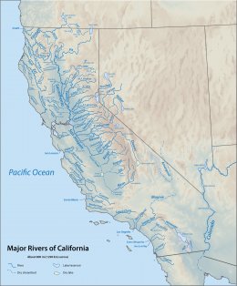
Loading Image...
Loading Image...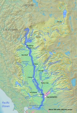
Loading Image...
Loading Image...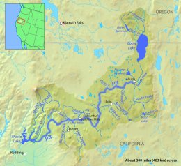
Loading Image...
Loading Image...
Loading Image...
Loading Image...
Loading Image...
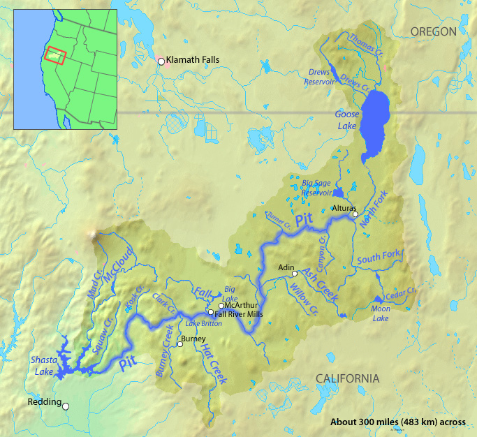
http://en.wikipedia.org/wiki/Pit_River
That Goose Lake that the Pit Rivers connects from is some alkaline or saline
probably toxic lake.
http://en.wikipedia.org/wiki/Klamath_River
http://en.wikipedia.org/wiki/Trinity_River_(California)
http://en.wikipedia.org/wiki/Columbia_River
http://en.wikipedia.org/wiki/Upper_Klamath_Lake
http://www.geo.hunter.cuny.edu/tbw/ncc/Notes/chapter12.humans.env/transferring.water.from.one.place.to.another.html
According to this website: "alfalfa, one of the most water-intensive crops,
is grown in the southern California desert. It uses about one-fourth of
California's irrigation water but makes up only 0.1% of the state's
economy." Is this true?!? Is there any reason to grow alfalfa? Of course,
what is 0.1% of the state's economy? What percent of the state's produce is
this? argh
All this stuff is just supposed to be informative. Nothing is conclusive.
We need to think freely, and optimistically, and positively, of ways to
store and obtain water in California. Don't let them tell you it can't be
done! Think outside the box!
As I said above:
One idea to take note of, is to make another Lake/Reservoir like Lake
Trinity out of the Klamath River. This river apparently is currently
emptying into the ocean. A lake just past the South Fork of the Trinity
River might be a possible location. The South Fork already connects to the
Lake Trinity. Another idea could be anywhere along the South Fork of the
Trinity River after the part that connects to Lake Trinity branches off:
http://upload.wikimedia.org/wikipedia/commons/2/24/Klamathmap.jpg
According to one website, the Central Valley produces one-third of all
produce grown in the United States. So this matters people!!
http://poseidonwater.com/
Carlsbad will be the largest seawater desalination plant in the Western
Hemisphere.
Project Capacity: 50 million gallons per day
The Huntington Beach Desalination Facility is a 50-million gallon per
day project currently in late-stage development.
Project Capacity: 50 million gallons per day
http://www.sacbee.com/news/state/california/water-and-drought/article3017597.html
They are building the Carlsbad Desalination Project, which will convert
as much as 56 million gallons of seawater each day into drinking water
for San Diego County residents. The project, with a price tag of $1
billion, is emerging from the sand like an industrial miracle. In
California’s highly regulated coastal zone, it took nearly 15 years to
move from concept to construction, surviving 14 legal challenges along
the way.
The water will cost $2,257 per acre-foot, about double the price of the
authority’s most expensive current supply, which is water imported from
the Sacramento-San Joaquin Delta more than 400 miles away.
Under this so-called “take-or-pay” contract, the water authority can
purchase an additional 8,000 acre-feet each year if necessary, which
reduces the price slightly, to about $2,000 per acre-foot.
One acre-foot is enough to serve two average homes for a year. At a
total output of 56,000 acre-feet, the plant will meet 7 percent of San
Diego County’s annual water demand.
A water shortage in the state of California is unacceptable.
California needs a canal from Oregon to the 2 great lakes in Northern California -
Lake Trinity and Lake Shasta.
Farmers should never be without water in the U.S.A. Farms and universities are
among the foundations of any country.
http://en.wikipedia.org/wiki/List_of_largest_reservoirs_of_California
http://en.wikipedia.org/wiki/Trinity_Lake
http://en.wikipedia.org/wiki/Shasta_Lake
Okay, here is a repost of what I have learned in case anyone is interested in
this, and it helps anyone to have these links (below).
3 rivers cross the Cascades, the Columbia River, the Klamath River, and the
Pit River. The Columbia River runs through the Portland/Vancouver, Oregon
area in the north of Oregon State, and forms most of the border between
Oregon State and Washington State.
The Klamath River and the Pit River cross the Cascades in Northern
California. The Klamath River connects to Trinity Lake through the Trinity
River, and the Pit River connects directly to Lake Shasta. This map shows
the Cascades range and the rivers:
Loading Image...

One idea is to get more water into Lake Trinity or into Lake Shasta, so we
can get more water out of them.
But no one even yet answered my question: Do our canals even carry water to
the Central Valley from these effectively yet? The map of the California
water systems doesn't indicate:
Loading Image...

It looks like they connect to the Sacramento River.
However another idea is to make another Lake/Reservoir like Lake Trinity out
of the Klamath River. This river apparently is currently emptying into the
ocean. A lake just past the South Fork of the Trinity River might be a
possible location. The South Fork already connects to the Lake Trinity.
Another idea could be anywhere along the South Fork of the Trinity River
after the part that connects to Lake Trinity branches off:
Loading Image...

If not these, perhaps there's another river that can be turned into a
greater reservoir somewhere else in the state. I included some maps of all
the rivers below.
As for connecting California's Lakes and River's to greater water sources,
the Columbia River, along the Northern Oregon border, may be the first
Northern point, connecting it to the Klamath River of the Pit River. The
major rivers that run through Oregon, and connect to the Columbia River
however, the Willamette River, and the Deschuttes River, both run South to
North.
Perhaps we could connect by running a canal east of the Cascades.
As you can see from the Cascades map, this could connect to either the
Klamath or the Pit Rivers:
http://upload.wikimedia.org/wikipedia/commons/c/cc/Cascaderangemap.jpg
Or maybe we could damn up Wickiup Reservoir, the source of the Deschuttes
River - or some place along the Deschuttes River - and make the water run
South into the Pit River or the Klamath River instead of North into the
Columbia?
Loading Image...

Loading Image...
Loading Image...

Loading Image...
Loading Image...

Loading Image...
Loading Image...

Loading Image...

Loading Image...

Loading Image...

Loading Image...

http://en.wikipedia.org/wiki/Pit_River
That Goose Lake that the Pit Rivers connects from is some alkaline or saline
probably toxic lake.
http://en.wikipedia.org/wiki/Klamath_River
http://en.wikipedia.org/wiki/Trinity_River_(California)
http://en.wikipedia.org/wiki/Columbia_River
http://en.wikipedia.org/wiki/Upper_Klamath_Lake
http://www.geo.hunter.cuny.edu/tbw/ncc/Notes/chapter12.humans.env/transferring.water.from.one.place.to.another.html
According to this website: "alfalfa, one of the most water-intensive crops,
is grown in the southern California desert. It uses about one-fourth of
California's irrigation water but makes up only 0.1% of the state's
economy." Is this true?!? Is there any reason to grow alfalfa? Of course,
what is 0.1% of the state's economy? What percent of the state's produce is
this? argh
All this stuff is just supposed to be informative. Nothing is conclusive.
We need to think freely, and optimistically, and positively, of ways to
store and obtain water in California. Don't let them tell you it can't be
done! Think outside the box!
As I said above:
One idea to take note of, is to make another Lake/Reservoir like Lake
Trinity out of the Klamath River. This river apparently is currently
emptying into the ocean. A lake just past the South Fork of the Trinity
River might be a possible location. The South Fork already connects to the
Lake Trinity. Another idea could be anywhere along the South Fork of the
Trinity River after the part that connects to Lake Trinity branches off:
http://upload.wikimedia.org/wikipedia/commons/2/24/Klamathmap.jpg
According to one website, the Central Valley produces one-third of all
produce grown in the United States. So this matters people!!
I think desalinisation has been tried in places like Marin, but it's still too
expensive.
Would it be to much to ask for you to speak knowledgeably about your state?expensive.
http://poseidonwater.com/
Carlsbad will be the largest seawater desalination plant in the Western
Hemisphere.
Project Capacity: 50 million gallons per day
The Huntington Beach Desalination Facility is a 50-million gallon per
day project currently in late-stage development.
Project Capacity: 50 million gallons per day
http://www.sacbee.com/news/state/california/water-and-drought/article3017597.html
They are building the Carlsbad Desalination Project, which will convert
as much as 56 million gallons of seawater each day into drinking water
for San Diego County residents. The project, with a price tag of $1
billion, is emerging from the sand like an industrial miracle. In
California’s highly regulated coastal zone, it took nearly 15 years to
move from concept to construction, surviving 14 legal challenges along
the way.
The water will cost $2,257 per acre-foot, about double the price of the
authority’s most expensive current supply, which is water imported from
the Sacramento-San Joaquin Delta more than 400 miles away.
Under this so-called “take-or-pay” contract, the water authority can
purchase an additional 8,000 acre-feet each year if necessary, which
reduces the price slightly, to about $2,000 per acre-foot.
One acre-foot is enough to serve two average homes for a year. At a
total output of 56,000 acre-feet, the plant will meet 7 percent of San
Diego County’s annual water demand.